|
|
overview:
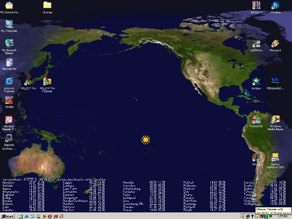
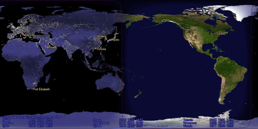
This software displays two versions of the world map, a day, and a night version,
and fades between them to show which portions of the world are in daylight,
and which aren't. In other words, this is a dynamic wallpaper that
updates based on where the sun is relative to the surface of the earth.
Version 0.12 is the most stable so far. Users of previous versions are encouraged
to upgrade.
If you have problems, take a look at the 'known
problems' section first.
contact:
- Due to excessive problems with spam, both to email and to the forums, I will no longer be reading either. I may check gmail every once in a while and let google deal with the spam.
license:
- This is copyrighted free software. Use it as you will, subject to the
license details found in both the setup program and the license.txt file available
after installation
- A copy of the most recent license.txt may be found
here. This license supercedes all licenses on
this page. If you download any other than the most recent version of the software,
this license applies to them as well, and you must make sure that this license
file is included in any redistribution of the software. If you happened to
have downloaded earlier versions of the software before this license was available,
the earlier version of the license shall apply to the software: you are not
required to update the license of your copy of the software just because I
choose to update the license here. However, if you download another copy of
the software after a later version of the license is available, you shall
be subject to the terms of the latest version of the license.
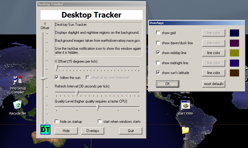
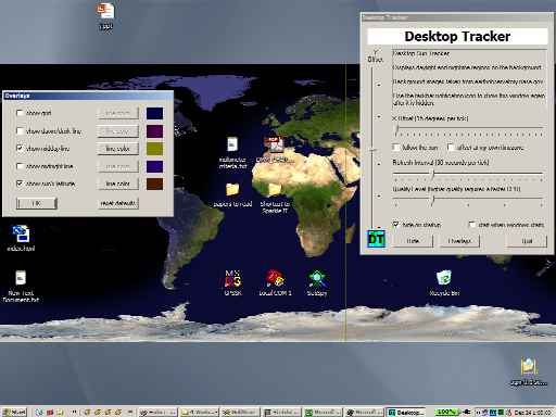
screenshots:
features:
- see if your contacts around the world are in daylight or not
- quickly see where the sun is relative to the surface of the earth
- see the dusk/dawn line (seasonally pretty accurate)
- configurable refresh intervals, map x offset, quality levels
- smooth dawn/dusk fading using dithering image merging
- configurable overlays for pinpointing sun position
- displays over the background image so you can see part of your background
(note that non-bmp backgrounds for windows versions prior to XP will cause
active desktop to be enabled).
known problems:
- This program probably will not work if active desktop is enabled. It is
known that it will not work on windows 98, 2000, and XP if active desktop
is enabled (as of December, 2002). I do not intend to fix this problem as
I don't use active desktop myself. Also, I suspect that the problem will not
be very easy to fix without extensive rewriting. If you must use active desktop
for some reason, I suggest that you use NASA's
jtrack,
a java satellite tracking applet which will run in an active desktop session.
- The screen does not refresh properly sometimes. This may be solved by
making a window cover the desktop (e.g. by maximizing it) and then uncovering
the desktop.
- Cities like Cairo and Jerusalem are GMT+2. Unfortunately, I still haven't
hooked into a time zone database so the time zone calculations are done based
on relative location to Greenwich, England. Consequently, cities like Cario
and Jerusalem will be off by one hour. Thanks to David for pointing this out.
- Daylight savings time is ignored -- this is another consequence of not
using a time zone database.
- Sometimes the program hangs under heavy loads. I'm not sure why yet. The
solution is to go to task manager, end the explorer process, and then restart
it again.
- You must have a desktop wallpaper selected. If you don't, desktop object
icons will not have proper borders.
- Problems reported running this program under some installations of Windows
98... I've only tested under Windows 2000 and XP.
porting:
- This project makes a lot of win32 calls so porting is not feasible. In
particular, the windows desktop is subclassed and hooked during operation.
- The rest of the code may be commonly found in many implementations (3d
geometry, etc.) elsewhere. As it is currently ugly, it will not be released.
resources:
- Background images may be found at
earthobservatory.nasa.gov or
more specifically at
earthobservatory.nasa.gov/Newsroom/BlueMarble.
- The ColorStaticST subclass (not used in version 0.8 and later) may be
found here.
- The installer is InnoSetup, which may be found
here.
- XEarth is a similar program that I found. It may be found
here. You may want to use that
one instead (it has a different feature set: e.g. it uses wallpaper switching
instead of subclassing the desktop).
- Coordinate data derived from the world population dataset found at
GRID-Arendal.
GRID-Arendal was used because it was the first world-spanning dataset with
coordinate data returned by Google. Only
coordinate data is used, but if I am in violation of licensing terms, please
email me and I will switch to a different coordinates dataset. Note that this
coordinates dataset is not very comprehensive and I may switch to another
one in the future anyway.
- NOAA sunset / sunrise calculation algorithms can be found
here.
download:
As is common practice, you should uninstall older versions of the program
before installing a new version.
version 0.6 (December, 2002)
- initial general release
- still available for
download, but this license supercedes the one
found in the archive.
version 0.7 (December, 2002)
- support for full screen display
- still available for
download, but this license supercedes the one
found in the archive.
version 0.8 (January, 2003)
- screen resizing bug-fix
- support for plotting city locations
- still available for
download, but this license supercedes the one
found in the archive.
version 0.9 (January, 2003)
- uses simple sunrise and sunset calculations from NOAA
- switched from degrees-decimal to degrees-minutes-seconds for coordinates
display
- interim release: status information cannot be hidden
- still available for
download, but this license supercedes the one
found in the archive.
version 0.10 (January, 2003)
- added an 'ignore Antarctica' option
- added a 'no city lights' option for night time viewing
- switched to a tabbed interface for the control panel
- fixed some data conversion problems for the city database
- low resolution version (runs well for most machines) still available for download but this license supercedes the one found in the archive.
- high resolution version (requires a faster CPU and more memory) still available for download but this license supercedes the one found in the archive.
version 0.11 (February, 2003)
- improved rendering times
- tray information is slightly more useful: you can pick a city to watch
the sunrise and next sunset for in the system tray area
- fixed bug with time zones east of GMT
- fixed synchronization bug that would cause the desktop to hang if too
many other applications were running
- low resolution version (runs well for most machines) still available for download but this license supercedes the one found in the archive.
- high resolution version (requires a faster CPU and more memory) still available for download but this license supercedes the one found in the archive.
version 0.12 (March, 2003)
- improved rendering times and quality (at the expense of more memory being
used)
- fine control over dawn/dusk line width in 'misc'
- switched location of HIDE and QUIT buttons to promote HIDE'ing instead
of QUIT'ing
- added a sun glyph
- improved program stability
- Cities like Cario and Jerusalem are GMT+2. Unfortunately, I still haven't
hooked into a time zone database so the time zone calculations are done based
on relative location to Greenwich, England. Consequently, cities like Cario
and Jerusalem will be off by one hour. Thanks to David for pointing this out.
- this version is likely going to be the last stable version for a while:
the upcoming versions are going to emphasize features over stability
- low resolution version (runs well for most machines) still available for download but this license supercedes the one found in the archive.
- high resolution version (requires a faster CPU and more memory) still available for download but this license supercedes the one found in the archive.
next version(s)
- March, 2004: next version is delayed because I need to finish my thesis first...
- switch to more accurate NOAA sunrise and sunset time calculations
- use proper time zones instead of the 15 degrees per hour assumption
- sun and moon glyph overlays
- city label and status text font selection
- add custom cities
- export current image to a file
- better crash recovery
- time offset bands (both GMT relative, and local time zone relative)
- XP-style text shadows
- relative sun angle from observer position
- overlay (underlay) support for smoother animation
- experimental dual monitor support
|